A forest walk with a detour to the top of The Scalp – panoramic views, but not for the faint-hearted!
Finally, following week after week of downpours any time I was off work, we’ve had a couple of days sunshine and I’ve been able to undertake a little exploration that I’ve wanted to do for years – seeing if the top of “The Scalp” was accessible by an easier route than just climbing up the sides!
If you have ever driven to Enniskerry or travelled on the 44 bus you will know The Scalp – a very steep sided gorge where the road seems to go straight through the centre of a huge rocky hill, with jumbled loose rocks of varying sizes overhanging the road and “falling rocks” signs. I’d often wondered what the view was like from the top, but the route up the sides from the road looks very sheer and dangerous for someone who is just a walker rather than a climber.
Local exploration had shown me that a small road – Barnaslingan Lane – runs behind The Scalp on the eastern side, and my plan was to approach from that direction. When coming from Dublin and Dundrum, Barnaslingan Lane is on the left, a mile or so before The Scalp, but very easy to miss, as both the turning, and the road sign showing it are hidden by hedges. Basically you pass the Golden Ball pub and the filling station at Kiltiernan, and pass the new traffic lights that control the junction with the Ballycorus Road. Carry on towards Enniskerry, and when you see a long straight row of old cottages on your right, the turn for Barnaslingan is on your left, as you reach the end of the row.
A couple of km along this narrow lane there is a forest park on the right – easy to miss, but it is directly opposite the first turning on your left.

Forest Park gate – click on any thumbnail for fullsize picture
This park, despite having signs proclaiming that the gates get closed at 8pm, never seems to be actually opened – several time I have passed during the daytime it has always been closed. The somewhat strange hypenation of “To-morrow” in the sign is also unusual!
There is just room for a car or two to park on the side of the road, as long as you in as close to the hedge as possible. Few people come here, so there should usually be a space. Once you have parked, pedestrian access through the gates is easy.
Once in the carpark, I took the smaller of two pathways on offer, which seemed to be the one leading most directly upwards.

The pathway was clear in some places, and slightly overgrown in others, presumably little used because people pass by if they can’t drive in. It was quite walkable though, even in the overgrown sections.
After crossing through an open area where high voltage ESB lines cross the forest, the path rose gently between mature trees. So far, so good, as long as I was heading upwards and directly west I was fairly sure I was bound for the top of The Scalp.

After about half a km the path comes to a T junction, with the main path going to the left. I followed this for a while, but turned back when it was clear that it was going downhill again and away from the hilltop. I retraced my steps to the T, and took the other fork, more overgrown. Almost directly after taking this, there was a small path on the left, leading directly to a low point on an old stone wall that seems to encircle the top of the hill.

The wall has an obvious crossing point, and climbing over it, and scrambling up a rock just beyond it are the only mildly difficult parts of the trip.
Few people use the forest park, and fewer still go beyond the wall, and although there is a fairly clear path through the trees and undergrowth, the area was wonderfully still and utterly silent, and I frequently came across birds and small animals who seemed startled to see me.

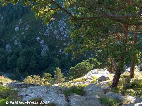
The ground here was uneven, but easy enough to cover, climbing over large smooth embedded rocks, and choosing trails that seemed to head in the direction I wanted to go in. For about 10 to 15 minutes I followed trails through bracken and scrubland, heading southwest and beginning to descend slightly. I still wasn’t sure at this stage that I would get to a point where I was on the top of the steep sides of The Scalp, but finally the great cleft in the hillside came into view ahead of me, and a stunning vista across the Wicklow countryside came into view, dominated by The Sugarloaf (a future walking ambition of mine).

The picture above (click on thumbnail for fullsize) shows the view towards The Sugarloaf. If you look carefully, the top of the spire of Enniskerry church can just be seen in the middle distance, a little to the right of the centre of the picture. The village itself is hidden in a hollow at the foothills of The Scalp. The Enniskerry Road can also be seen, and some of the houses around the Ballyman Road.
Very shortly beyond this, I came to the edge of The Scalp, where there are some flat rocks to sit on a safe few metres away from the edge, which is steep enough to make even me nervous. Unfortunately a strong sun was setting directly on the other side somewhat restricting my photography options, through trees could sometimes be used as cover.

Above: Destination reached – standing on the edge of The Scalp, with the road far below.
I won’t be archiving this into the “Walks By Car” section, as I feel that the last part offers too much scope for the unwary to have accidents, especially if they take some other trail for the final few minutes, and perhaps come to some sheer drop that I did not myself encounter. it is safe enough for anyone cautious and level-headed, butI certainly would not reccomend it if you are walking with children!

While sitting on the top, a 44 bus passed way below, and I used the zoom lens to get a birds eye shot. Unfortunately the sun intervened again, and the circular discoloured area in the lower left is a reflection of direct sunlight on the lens.
The Scalp itself is right on the border between Counties Dublin and Wicklow – I’m sitting in Co. Dublin, but the bus is in Co. Wicklow at this point (although about to cross back into Dublin very shortly).
All in all, a nice after-work walk, a chance to realise a long held ambition, and after all the rain, it was great to be out and walking again.
Fat Steve

I’ve done this walk today, thanks to you! It was easy enough to find the starting spot, and the pics helped, especially the to-morrow notice.
The walk is really easy, was hoping for a more uphill challenge, but this would be ideal to walk before a family picnic on the benches close to the starting point.
Saw lots of deer droppings, but unfortunately no deer.
Loved the view from where you took the bus pic, sat there for a good half hour thinking about life. PS. What is it they are building to the right? Some really big condstruction going on there.
Thanks again for your descriptions!
Hi Annette, thanks, this is exactly why I love to put up pictures and share my walks.
There are a few good steeper ones easily reachable from Dublin – don’t know if you have ever done the Hell Fire Club one, but its a good climb with the reward of an old ruin to explore and a good view from the top.
There is also a good walk that can be done right over the top of 2 and 3-rock mountains, which I’ll publish shortly.
I’m re-doing all of these to get the pictures I need for here (and for the excercise of course) as I don’t want to put anything up unless I can show good shots, and am sure that my directions are up to date and accurate.
Anyway, glad you enjoyed the walk, check back here for more soon.
The construction you talked about might be the renovation and rebuilding of the Sports Hotel, its at the Dublin end of The Scalp.
Regards
FatSteve
Nice page great pictures coming to Dublin 30/05/08 thanks for the preview
Hi Steve
I’m delighted to have come across your blog. I am planning on doing a short hike/ walk soon with some friends. None of us would have much experience and I’m not sure of fitness levels. People in there mid 20’s to larte 30′ so should be reasonably fit. I used to hike a lot when i was younger- I was in the scouts. I always remeber the hike up to the scalp and then on into Bray. Its been over 20 year ago so not sure if that’s still achievable. So a couple of question if you can rememeber. How long does it take to get up ? Have you ever done the hike down into Bray? Is the large chimney structure still up on top of the Scalp?
I might have a look for some other walks and hikes while I’m here. Great blog.
Thanks
Alan