Feeds:
Posts
Comments

Hello all,

As promised, I have started to update the site and add new walks. The first is the Sutton to Clontarf Seafront Walk, easily accessible by public transport.

Good quality segregated walkway, suitable for all ages and wheelchairs.

The is the first of the new walks to include enhanced features – a map, as well as a 360 degree video clip taken along the route to give you a better idea of what it looks like.

As for myself, I’m continuing to walk every day, and feeling better for it. More walks to be added soon!

Fat Steve


As promised a few times before, I have finally got back to regular walking, and have walked almost every day during the last month, including over Christmas.

The above shows my last month, with walks every day (green, red or yellow notations) and comes from a wonderful smartphone app which I’m using to help me track my walking, and which will aid me in better illustrating and mapping the walks on here for you in the future.

It’s called WalkMeter – http://www.walkmeter.com – and as well as informing me as i walk how far I am going (I have it set to whisper to me at half kilometer increments) it gives me a wealth of details and a GoogleMap afterwards.

So, the walking is back, and I aim to keep it up.

I also have plans to greatly increase the content of the site – new walks will feature maps and video clips as well as photos and descriptions.

I have two walks by bus and one by car in preperation  – should be published here within the next week – and more to follow.

Thanks for your patience and continued visits furing the fallow period on this site, and I look forward to seeing more of you (and less of me in terms of bulk) in 2012.

Fat Steve

Time to Continue

Hi all,

I have rather neglected both the walking, and this blog for some time.

Just logging in now to find your many comments, and a lot of continuing traffic to the blog is the inspiration that Ineed to get walking – and writing – again.

So I promise more walks and updates very soon – hold me to it!

FatSteve


More updates

Hi all,

Have a stack of new walks to add shortly!

Fat Steve

Hey all.

After a long winter, and a foot operation that kept me off the walks for a while, I hope to be bringing you new walks and pictures very shortly

Thanks for all the nice comments.

Fat Steve

Donadea Forest Walk

A gentle 6km forest walk within easy reach of Dublin, with a ruined castle and a 9/11 memorial.

Donadea Header

The return of good weather at last has seen me looking to take slightly longer walks again – I’ve been trying hard to keep up my walking to fitness routine through the rainy days, but not blogging it, as I’m fairly sure that “walked up and down xyz road for the fifth time this week” would not exactly make for exciting reading.

I was lucky enough to have today (Monday 27th August) off work, and decided to head off in the car to somewhere I had not been before. A quick scan of the Coillte website – http://www.coillte.ie – turned up Donadea as a good possibility: not too far from Dublin, big enough to have a a 5+ km walk, and not somewhere I have been before.

Getting to Donadea in Co. Kildare is fairly easy, though the directions on the Coillte website do lack some vital details. You can reach it either by taking the R407 south from the Kilcock junction of the M4, or the R407 north from the centre of Naas.

Coillte would give you the impression that the forest park is actually on this road, but it is 3 or 4 km west of it, reached via a righthand turn (if coming from the M4) or lefthand (from Naas) – just look out for the brown tourist sign marking the turnoff, and follow that. The park will eventually be on your left.

Entry fee is €4 per car, payable in exact money only, to a mechanised barrier, which only accepts €1 or €2 coins. Once inside the park there is ample car parking and also a shop and toilets (which we will come to later).

At the bottom of the car park there is a good map of the park, on which our walk is clearly marked in blue.

Donadea map

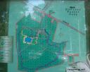
(click on any small image to see fullsize version – this one is particularly useful, as it’s a photo of the map!)

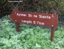
There are various walks possible in the park, my choice being the blue, or “Aylmer” walk, which is the longest, circling most of the forest. This can be walked in either direction, but I chose, and would reccomend, clockwise, as it saves the lake, the tea shop and the ruined castle for the end rather than having them near the beginning.

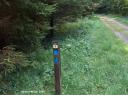
To do the walk in a clockwise direction, head back from the carpark towards the entry road, and the walk is just beyond the end of the car park, on your right if the car park is behind you, and very clearly signed.

Walksign

From here the walk proceeds to the east, along a gravel surfaced pathway. After about 500m you will reach a T and turn to the right – this and all major junctions are clearly signposted for all the different walks. Just keep following the blue signs.

Bluesign

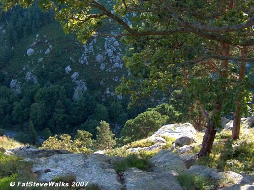
Walking now along the eastern side of the forest, the route passes through a large area of mostly pine trees, and being the longer walk, is less popular, and for the most part deserted.

conifirs

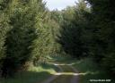
The planting, as usual with pine forests, is very dense, with occasional larger and smaller firebreaks, pathways and ditches leading off on either side.

One narrow firebreak leading between trees was almost tunnel-like, and very dark, and I couldn’t resist venturing some way down it in order to try getting shots at different exposure levels to see how the patterns of light and shade looked in picture.

Light & Shade

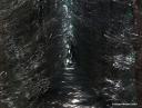
Re-emerging suddenly from this hidden pathway onto the main track I did rather startle two young walkers who must have thought themselves alone on this seemingly empty track, and they looked anxiously at each other as I appeared in front of them, busy tucking my shirt in from where it had come out as I crouched down to get the best camera angles. They looked quite relieved when I purposefully waddled off in the other direction!

The walk around the eastern and southern sides of the forest is peaceful and lovely, and here and there are dotted benches for the weary. The circular nature of the trail also means that to cut the walk short, you simply have to take one of the intersecting paths to the right, though I’d reccomend the full 5.7km if you are up for it.

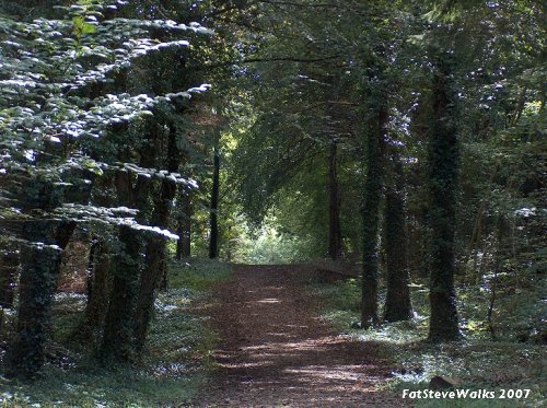
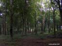
Gradually the end of the southern boundary is reached, and the pathway turns north, now leading through mostly mixed native woodland.

Mixed

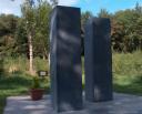
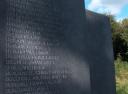
This part is mostly uphill, though fairly gentle. A little while after passing a turning labelled “nature walk” to the right, theblue trail itself turns to the right, and heads through a plantation of ash towards the forest’s 9/11 memorial site.

The memorial, standing in the middle of peaceful forest, is both well designed and also very peaceful.

Two stone pillars are placed in the size and positioning of the Twin Towers, and are inscribed with the names and ranks of the firefighters, police, and port officials who died in the rescue attempt, while nearby benches are dedicated to the passengers on the hijacked planes.

911a

911b closeup

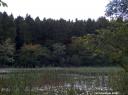
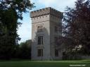
From here the pathway curves back to head towards the centre of the forest, where the lake and tearooms are, though before reaching them it passes one side of the ruins of an old castle.

castle1

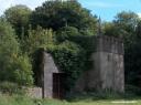
Very shortly beyond the castle, the lake is reached, and this marks the end of the walk, the car-park being reached by a main avenue leading past the tea rooms and the from of the ruined castle.

lake

castle2

The entire walk took me about an hour and a half, though this was with frequent stops for photographs, and a few side trips (and the odd scaring of other walkers!). A fitter walker could easily do it in an hour.

I’ll be putting this up on the “Walks by Car” section in due course.

More soon, if the weather holds, if not, its back towalking up and down xyz road in the rain.

Fat Steve

Scary Scalp Walk

A forest walk with a detour to the top of The Scalp – panoramic views, but not for the faint-hearted!

Scalp Header

Finally, following week after week of downpours any time I was off work, we’ve had a couple of days sunshine and I’ve been able to undertake a little exploration that I’ve wanted to do for years – seeing if the top of “The Scalp” was accessible by an easier route than just climbing up the sides!

If you have ever driven to Enniskerry or travelled on the 44 bus you will know The Scalp – a very steep sided gorge where the road seems to go straight through the centre of a huge rocky hill, with jumbled loose rocks of varying sizes overhanging the road and “falling rocks” signs. I’d often wondered what the view was like from the top, but the route up the sides from the road looks very sheer and dangerous for someone who is just a walker rather than a climber.

Local exploration had shown me that a small road – Barnaslingan Lane – runs behind The Scalp on the eastern side, and my plan was to approach from that direction. When coming from Dublin and Dundrum,  Barnaslingan Lane is on the left, a mile or so before The Scalp, but very easy to miss, as both the turning, and the road sign showing it are hidden by hedges. Basically you pass the Golden Ball pub and the filling station at Kiltiernan, and pass the new traffic lights that control the junction with the Ballycorus Road. Carry on towards Enniskerry, and when you see a long straight row of old cottages on your right, the turn for Barnaslingan is on your left, as you reach the end of the row.

A couple of km along this narrow lane there is a forest park on the right – easy to miss, but it is directly opposite the first turning on your left.

scalp1

Forest Park gate – click on any thumbnail for fullsize picture

This park, despite having signs proclaiming that the gates get closed at 8pm, never seems to be actually opened – several time I have passed during the daytime it has always been closed. The somewhat strange hypenation of “To-morrow” in the sign is also unusual!

There is just room for a car or two to park on the side of the road, as long as you in as close to the hedge as possible. Few people come here, so there should usually be a space. Once you have parked, pedestrian access through the gates is easy.

Once in the carpark, I took the smaller of two pathways on offer, which seemed to be the one leading most directly upwards.

scalp2

The pathway was clear in some places, and slightly overgrown in others, presumably little used because people pass by if they can’t drive in. It was quite walkable though, even in the overgrown sections.

After crossing through an open area where high voltage ESB lines cross the forest, the path rose gently between mature trees. So far, so good, as long as I was heading upwards and directly west I was fairly sure I was bound for the top of The Scalp.

scalp3

After about half a km the path comes to a T junction, with the main path going to the left. I followed this for a while, but turned back when it was clear that it was going downhill again and away from the hilltop. I retraced my steps to the T, and took the other fork, more overgrown. Almost directly after taking this, there was a small path on the left, leading directly to a low point on an old stone wall that seems to encircle the top of the hill.

scalp4

The wall has an obvious crossing point, and climbing over it, and scrambling up a rock just beyond it are the only mildly difficult parts of the trip.

Few people use the forest park, and fewer still go beyond the wall, and although there is a fairly clear path through the trees and undergrowth, the area was wonderfully still and utterly silent, and I frequently came across birds and small animals who seemed startled to see me.

scalp5

The ground here was uneven, but easy enough to cover, climbing over large smooth embedded rocks, and choosing trails that seemed to head in the direction I wanted to go in. For about 10 to 15 minutes I followed trails through bracken and scrubland, heading southwest and beginning to descend slightly. I still wasn’t sure at this stage that I would get to a point where I was on the top of the steep sides of The Scalp, but finally the great cleft in the hillside came into view ahead of me, and a stunning vista across the Wicklow countryside came into view, dominated by The Sugarloaf (a future walking ambition of mine).

scalp6

The picture above (click on thumbnail for fullsize) shows the view towards The Sugarloaf. If you look carefully, the top of the spire of Enniskerry church can just be seen in the middle distance, a little to the right of the centre of the picture.  The village itself is hidden in a hollow at the foothills of The Scalp. The Enniskerry Road can also be seen, and some of the houses around the Ballyman Road.

Very shortly beyond this, I came to the edge of The Scalp, where there are some flat rocks to sit on a safe few metres away from the edge, which is steep enough to make even me nervous. Unfortunately a strong sun was setting directly on the other side somewhat restricting my photography options, through trees could sometimes be used as cover.

scalp7

Above: Destination reached – standing on the edge of The Scalp, with the road far below.

I won’t be archiving this into the “Walks By Car” section, as I feel that the last part offers too much scope for the unwary to have accidents, especially if they take some other trail for the final few minutes, and perhaps come to some sheer drop that I did not myself encounter. it is safe enough for anyone cautious and level-headed, butI certainly would not reccomend it if you are walking with children!

scalp8

While sitting on the top, a 44 bus passed way below, and I used the zoom lens to get a birds eye shot. Unfortunately the sun intervened again, and the circular discoloured area in the lower left is a reflection of direct sunlight on the lens.

The Scalp itself is right on the border between Counties Dublin and Wicklow – I’m sitting in Co. Dublin, but the bus is in Co. Wicklow at this point (although about to cross back into Dublin very shortly).

All in all, a nice after-work walk, a chance to realise a long held ambition, and after all the rain, it was great to be out and walking again.

Fat Steve


I’m still here, and still walking, but somewhat frustrated in my ambitions to redo my favourite longer walks to put them on here, due to the almost constant rain for the last month, which has neatly coincided with every free day or evening!

Have plans to put a mountain walk and some more coastal ones online as soon as I can update the pictures, more soon . . .

Fat Steve

With open vistas in every direction, and a cool breeze on even the hottest day, the Great South Wall is the hidden gem of Dublin Bay.

NOTE: Full details and directions for this walk can be found in our Walks by Car section. A version for bus access and including Irishtown Nature Reserve will be produced shortly.

Fat Steve had a fairly good weekend just gone, though with a little less opportunity for walking than might have been hoped. It started off with a trip up the mountains with some work colleagues, including JS the American who was amazed to see the Irish cotton fields (well, OK, peat-bogs with cotton plants growing on them) and AC the Comedy German, who wanted to see the German Cemetary at Glencree. I’m sure AC plays up to his national stereotypes, but the questions “what is the purpose of this plant with purple flowers?” (heather) and “Why is it planted randomly all over the hillsides?” was apparently asked in all seriousness.

There wasn’t much chance for walking, and I was busy all weekend so after finishing work at 9pm on the hot sticky Sunday evening, I opted for one of my favourite treats, a cooling walk out along the hidden gem that is Dublin’s Great South Wall.

Many people have never heard of it, others wouldn’t know exactly how to get to it, but those that do, swear by it. Built in the late 1700s it is in effect a massive pier that stretches more than 2km out into the middle of the bay from a starting point near the Pigeon House.

On hot summer evenings it is just the thing – no matter how still the air, there is always a gentle cooling sea breeze. The views of the city and mountains are stunning – you can see the whole of the bay and up the Liffey, quite a unique viewpoint.

Dublin Bay South

Click on any thumbnail to see fullsize image

It’s an easy walk, can be taken at any pace, and at Fat Steve Speed takes around 35 minutes in each direction, from the car parking area to the tip with the lighthouse.

There are always some people walking the wall, more so in summer, and this Sunday there were quite a few enjoying the late evening. A large party of Polish fishermen were busy piling up stacks of what looked to me like Sea Trout, whatever they were, the time was right for catching, as they were leapingout of the water all the way along the wall.

Walking the wall, there is always lots of activity to see, with arriving and departing shipping, in this case the Norfolk Line and the P&O as well as some freighters.

Great South Wall sunset

The sunset is superb too, if you time it right, and arriving back at the car as it was getting later, I was surprised to see a fox, as I would have thought this area too remote from the city and food sources.

The drive to and from the wall, along Pigeon House Road is very atmospheric, all post industrial with decaying buildings, scrapyards and scrubland. Beside the modern Pigeon House complex itself you will see not only the red-bricked former generating house, now in disrepair, but also a much older military building, used as offices by the ESB.

One day soon, much of the abandoned landscape will be swept away by a gleaming new city quarter of glass, but the great wall, which has stood for hundreds of years, will remain.

Fat Steve

Two acheivments in the last 24 hours – this evening I’ve created the “Walks by Bus/Rail” page, and the first two of many subpages listing and giving directions for walks. These will be added to gradually to build up a library of walks, with directions on how to get to and from, starting point, directions, general info and cautions, and how to get back to Dublin afterwards. A “walks by car” section will follow.

And yesterday I took a good long walk that I’ve been thinking about for ages – all the way from Kilcock to Maynooth along the Royal Canal, about 7km of blissful rural tranquility. Well, six if you count the first stretch by the main road.

Bus route 66

On the 66 approaching Kilcock – click on any picture for fullsize version

Dublin Bus route 66 has occasional (and infrequent) extensions to Kilcock, and this was my outward travel, hence the cheesy post title.

Weighed down with rather too much in the way of coat, camera, bottled water – I really must get a rucksack – I headed off along the canal, which runs alongside the road for a while, before going its own way through the countryside.

Canal walk

Royal Canal, Co. Kildare

It was pretty hot, so I took my time ambling along at FSS (Fat Steve Speed) the entire walk taking just under two hours, but you could probably do it a lot quicker if you didn’t waddle breathlessly along the canal bank taking occasional breaks under shady trees as I did!

I’m pleased with myself though, as when I was a little more than halfway, I passed a lock with a short laneway leading to a nearby road on which a bus would shortly be passing, and despite the heat I didn’t even think of cutting the walk short and taking the convienient bus.

Well, maybe a little bit, but I resisted, and trudged on gamely, and enjoyed it too!

Bridge detail

 Various locks and barges on the way were of interest, and one bridge looked to be original to the construction of the canal, complete with details of the engineers.

Passing St Patricks College the tall trees of the grounds behind the high wall looked very inviting – why is it that walled in places seem so tempting?

St. Patricks College, Maynooth (wall)

I made it to Maynooth exactly in time for a 67A home, and a well earned shower and smugness.

I’m getting to like this walking lark.

I’ve written up the walk complete with lots of photos and directions (and minus the blog waffling) so check it out if you want to see more, or do this walk yourself.

Fat Steve